


Plans have been submitted to the Council for a £6.2 million project to defend against flooding and reconnect the River Avon to Bath city centre.
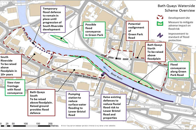
The Bath Quays Waterside Project would put in place essential flood mitigation and defence works to the north and south banks of the river between Churchill Bridge and Midland Bridge that address the negative impacts of climate change.
The Council is working with the Environment Agency on the major infrastructure proposal, which would provide flood defences for parts of Bath’s city centre and begin to improve accessibility for pedestrians and cyclists in the riverside environment.
Subject to approval, it is hoped to begin work in 2015.
The project would not increase flood risk up or downstream and would not stop other flood alleviation works going ahead elsewhere in the city.
The Council is working with the Environment Agency to re-evaluate options inside and outside of the new regeneration areas to ensure flood risk in Bath is managed as effectively as possible.
This includes considering the future roles and operation of Pulteney and Twerton gates.
Extensive public consultation took place in April and May this year to obtain feedback from local residents, businesses and other interested parties.
The project team consulted with landowners and affected parties adjoining the scheme, along with a number of statutory bodies including Natural England, English Heritage and Canals & River Trust along with representative stakeholders – including CycleBath, Sustrans, Bath Preservation Trust, Bath Chamber of Commerce and the Initiative in B&NES.
As a result of the public consultation, the following changes have been made:
- Amendments to the Green Park Road proposals include a change in the Avon Street car park exit location and the location of Corn Street pedestrian crossing.
- Various changes to proposed flood protection works to existing buildings on south river bank and adjacent flood walls.
- Proposed tree species on north bank including an increase in the range of maturity of trees to be planted.
The project could support the delivery of around 2,500 new homes, up to 650,000 square feet of new workspace and 9,000 new jobs for local people as part of the Bath City Riverside Enterprise Area.
It would overcome one of the major stumbling blocks to unlocking the potential of brownfield sites along the River Avon – the possibility of flooding.
The plans also aim to reduce existing and future flood risk to the Lower Bristol Road and over 100 residential and commercial properties on the South side of the river through the provision of new flood defences.
To view and comment upon the planning application, go to: www.bathnes.gov.uk/BathQuaysWatersidePlans.
To learn more about the project, visit: www.bathnes.gov.uk/bathquayswaterside.