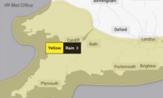
Locals are being warned to take care today and tomorrow after the Met Office issued a yellow weather warning for a large amount of rain set to cause some disruption.

The yellow weather warning was issued at 5.30am by the weather forecaster, with heavy rain expected to start at around midday with the likelihood of localised flooding across the area.
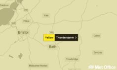
Showers will become heavy and thundery across southwestern parts of both England and Wales early on Friday, moving northeast to affect much of Wales, the Midlands, East Anglia and southern England during the day.
Some reduction in activity is expected on Friday night, before further slow-moving heavy and thundery downpours develop during Saturday, easing from the north later.
The public are being advised that the resulting downpours may lead to localised flooding and potential disruption to transport and outdoor events.
The Met Offices chief forecaster said: “A slack area of low pressure is expected to extend eastwards across southern UK on Friday and Saturday, bringing with it moist and deeply unstable air.
“Daytime heating will assist the development of heavy showers and thunderstorms. These are likely to become slow-moving and organised into bands giving some places 15-20 mm of rain in an hour or less and perhaps 40 mm in 2 or 3 hours.
“Hail and lightning will be additional hazards. As with the nature of showers, some places will escape the heavier ones.”